No products in the cart.
Heavy Payload
40 kg spraying[1]
50 kg spreading[1]
High Flow Rate
Spraying 16 L/min[3]
Spreading 108 kg/min[4]
Signal Stability
Offline operations
2 km O3 Transmission
Optional DJI Relay
$24,200.00
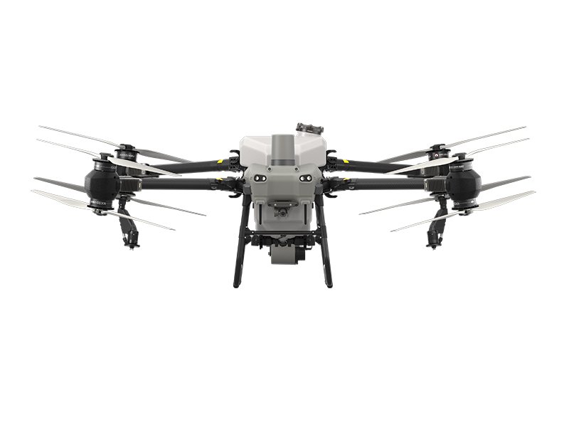
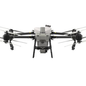
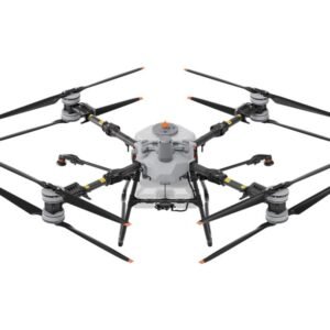
DJI Agras T50
DJI AGRAS T50 elevates drone agricultural operations to new heights. It inherits a powerful coaxial twin-rotor propulsion system and a split-type torque resistant structure for next level stability when carrying 40 kg spraying[1] or 50 kg spreading[1] payloads.
DJI AGRAS T50 leverages a Dual Atomizing Spraying System, Front and Rear Phased Array Radars, and a Binocular Vision System. DJI AGRAS T50 excels across multiple scenarios, from surveying[2] to spraying and spreading, guaranteeing stable operations and steady performance.
Heavy Payload
40 kg spraying[1]
50 kg spreading[1]
High Flow Rate
Spraying 16 L/min[3]
Spreading 108 kg/min[4]
Signal Stability
Offline operations
2 km O3 Transmission
Optional DJI Relay
All Scenario Adaptability
Fully automatic and manual operation
Orchard Mode
Variable Rate Application
Multidirectional Obstacle Sensing[6]
Multidirectional Obstacle Avoidance
Terrain Following up to 50°
Four Sprinkler Kit (Optional)
Reverse Directional Spray During Flight
4-sprinkler spraying, flow rate 24 L/min[3]
50 kg Payload[1]
75 L max capacity and an expanded loading gate for quick refills.
Smooth Spreading
The torque of the spreader is doubled and the discharge hatch is enlarged to enable a flow rate up to 108 kg/min[4].
Uniform Spreading
DJI AGRAS T50’s spiral channel spinning disk makes spreading more uniform.
Low Rate Spreading
You can also switch to small hopper gates to improve spreading accuracy with a low flow rate.
Real-Time Weighing
DJI AGRAS T50 is equipped with a weighing sensor which allows you to monitor the remaining payload in real time.
Fast Disassembly and Cleaning
The spreader can be quickly disassembled and cleaned for easy maintenance.
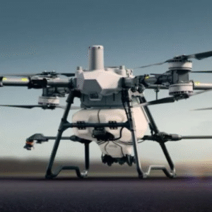
DJI AGRAS T50 is equipped with front and rear Active Phased Array Radars with double the number of RF channels[17] for higher detection precision. Together they enable Multidirectional Obstacle Sensing[6], elevating operating safety. Two sets of Binocular Vision sensors enable DJI AGRAS T50 to accurately sense terrain and depict obstacles in detail, for automatic obstacle bypassing[11] and Terrain Following[11] over steep slopes.
DJI AGRAS T50 integrates aerial surveying[2], spraying, and spreading into a single drone. A high-resolution FPV gimbal camera enables real-time capture of field and orchard images. Paired with DJI RC Plus and RTK service, you can generate high definition maps which underpin subsequent automatic flight routes. DJI AGRAS T50 can take off and perform automatic operations, all at the push of a button.
Orchard Aerial Survey[2]
DJI AGRAS T50 supports obstacle bypassing and Terrain Following for surveying[2] of orchards on slopes up to 20°[5]. With DJI RC Plus and its real-time mapping capabilities, it can automatically identify fruit trees and obstacles. Based on the distribution of the fruit trees, it can generate accurate and fully automatic 3D flight routes.
| Brand | |
|---|---|
| Model | |
| Category |
Agricultural Drones, Crystalsky Spares, Parts & Spares
Agras T50, Agricultural Drones
Agras T100, Agricultural Drones
Agras T100, Agricultural Drones
Agras T100, Agricultural Drones
Reviews
There are no reviews yet.